From 10 to 13 March 2025, HumanTech team partners from research institutes, SMES, and construction companies gathered at the Department of Biomedicine of the University of Basel construction site to evaluate one of the use cases of our dynamic semantic digital twin system. This technology contributes to our broader mission to digitalise the construction sector, enhancing safety and improving efficiency.
Read the insights from the team involved in this pilot’s development:
Applying BIMxD and scan-to-BIM in real-world scenarios
Fabian Kaufmann, Researcher at RPTU
The main objective of this pilot — one of our five HumanTech Pilots — is to demonstrate and validate HumanTech solutions related to BIMxD and scan-to-BIM in real-world applications. This includes five use cases:
- Construction progress monitoring
- Construction site item localisation
- Falling hazard identification using an interactive augmented user interface
- Detection of blocked emergency exits
- Scan-to-BIM to provide an as-is model of the project
Key milestones include the development of technical components such as a 360-degree depth camera and automated unmanned aerial vehicle (UAV) and unmanned ground vehicle (UGV) scanning pipelines for efficient data capture, segmentation models, scan-to-BIM reconstruction algorithms, and open BIM authoring tools. During the pilot implementation, each component was integrated to deliver the corresponding use case.
“The main objective of this pilot is to demonstrate and validate HumanTech solutions related to BIMxD and scan-to-BIM in real-world applications.”
Turning point clouds into actionable insights
Sebastian Mattes, Reality Capturing Specialist at Implenia
In this pilot, we explored how point clouds can be used effectively on construction sites, with a focus on two key areas: safety and productivity.
We employed different technologies to capture the data: a laser scanner, a drone, and a 360-degree camera with depth-measurement. By using reference markers, we could align these datasets, compare their accuracy, and overlay them with a digital model.
Capturing the point clouds is actually the smallest part; the real challenge lies in processing the data and extracting meaningful information from millions of points.
“Capturing the point clouds is actually the smallest part; the real challenge lies in processing the data and extracting meaningful information from millions of points.”
On the safety side, we aimed to detect and visualise falling hazards and ensure that emergency exits were unobstructed. From a productivity perspective, we developed a pipeline to generate a model from the point cloud, track the building progress, and identify materials or objects present on-site.
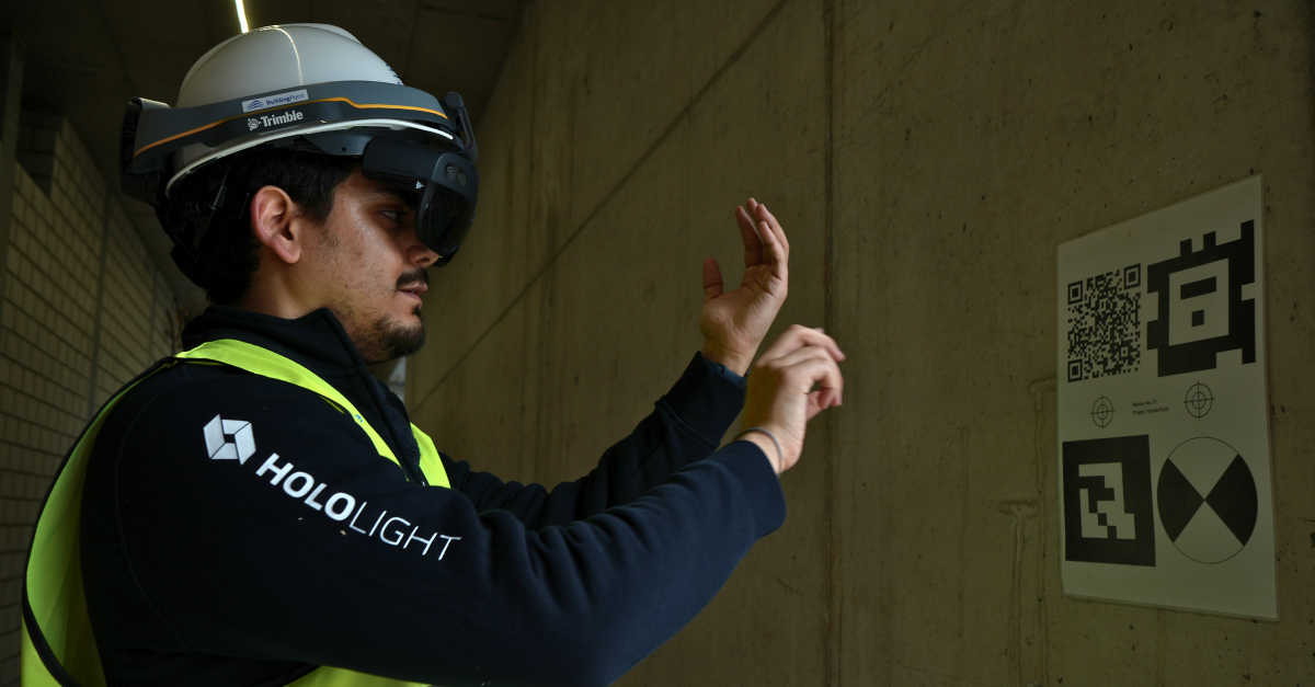
Hololight’s XR solution for the falling hazards detection use case
Harsh Manoj Shah, Technical Project Manager at Hololight
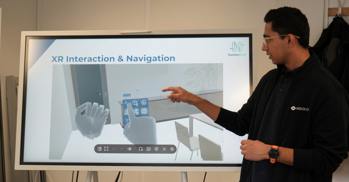
As part of the use case focused on detecting falling hazards, we at Hololight developed an XR-based BIM visualisation system called BIMSpace XR. It is a mixed reality application that enables real-time, true-to-scale visualisation of high-quality BIM models directly on construction sites. Using industry-standard markers, the system ensures precise alignment between the digital model and physical structures, giving construction professionals an immersive and interactive way to inspect safety-critical elements.
“The BIMSpace XR solution gives construction professionals an immersive and interactive way to inspect safety-critical elements directly on-site.”
The BIMSpace XR application is integrated with Hololight Stream, a remote rendering solution that enables real-time streaming of augmented reality (AR) and virtual reality (VR) applications from powerful servers to the Microsoft HoloLens 2 XR device. The solution also supports real-time issue tracking through the BIM Collaboration Format (BCF), allowing users to detect, annotate, and resolve design deviations, safety hazards, or construction errors on-site. These issues are synchronised with BIM collaboration platforms like Catenda Hub, enabling seamless project coordination and communication across teams.
In addition to progress tracking by comparing as-planned and as-built conditions, the solution can extend to MEP reviews, virtual safety training, and multi-user collaborative sessions, offering interactive and scenario-based learning experiences on-site.
Detection of blocked emergency exits using BIM and point cloud analysis
Marius Schellen, Reasearcher at RPTU
This use case focuses on improving safety on active construction sites and operational buildings by detecting blocked emergency exits in real time. Leveraging a detailed BIM model — either of a building under construction or in use — all doors marked as emergency exits (with the fire exit property set to true) are identified. From these, the system derives the required emergency corridors that must remain clear at all times to comply with safety regulations.
Using HumanTech’s advanced technologies, an up-to-date point cloud of the site or specific area is analysed. Points falling within the defined emergency corridors are examined to detect potential obstructions. A rule-based system then determines whether any objects actually block the escape path, ensuring that a minimum width is maintained for safe evacuation.
“Using HumanTech’s advanced technologies, emergency exits can be monitored in real time — helping teams resolve safety hazards quickly and efficiently.”
This functionality is fully integrated into the HumanTech BIMxD backend. Through a browser-based interface, users can upload or select an IFC model along with the corresponding point cloud to automatically detect obstructions with just a few clicks.
If an issue is found, a BIM Collaboration Format (BCF) report is automatically generated. This report can include attachments, instructions, or notes, and is assigned to the relevant project personnel, helping teams resolve safety hazards quickly and efficiently.
Item localisation with 360-degree 3D scanner
Hideaki Kanayama, R&D Engineer at RICOH
As part of this pilot, we conducted a field demonstration of our newly developed 360-degree one-shot 3D scanner at a construction site and applied it to the use case focused on construction site item localisation. High-speed scanning in the field is crucial to reduce the effort required to capture images while minimising disruption to site activities.
To compare the design BIM model and 3D scans, we developed a pipeline that aligns the scanned data with BIM using AR markers as reference points. This allows for visualising progress changes in comparison to the BIM model.
We also developed a data preprocessing pipeline to facilitate item localisation using Open-Vocabulary Segmentation, a technology developed by DFKI. Since conventional AI models often struggle with 360-degree imagery, we converted these images into a format more compatible with existing models — significantly improving their performance.

Enabling dynamic semantic digital twins through automated data capture
Michael Peter, Patipol Thanuphol, Researcher at ZHAW
As part of this pilot, ZHAW developed and integrated an automated data acquisition system designed to support the creation of Dynamic Semantic Digital Twins (DSDT) in construction. The system coordinates drones, robots, and handheld scanning workflows, enabling efficient, minimally disruptive data collection throughout the construction lifecycle.
“We developed an automated data acquisition system that coordinates drones, robots, and handheld scanners — enabling efficient, minimally disruptive data collection throughout the construction lifecycle.”
Capture requests are initiated and managed through BIM-based inputs, and the collected data is automatically processed, aligned, and integrated using a unified backend. A key innovation is the standardised marker system, which ensures accurate spatial referencing across different capture sessions and devices. Surveyed markers are paired with detectable visual targets, and their detection and transformation are automated within the pipeline.
The system also provides recommended marker information to project partners, simplifying downstream processing and dataset merging. These developments enable high-quality, consistent, and scalable 3D data capture — supporting use cases such as progress tracking, safety monitoring, and automated as-built model generation.
Bringing the end-user perspective
Patricia Rosen, Researcher at BAuA
Like in other HumanTech pilots, our focus in this pilot was to include the end-user perspective in the technology development process to obtain valuable feedback on the current system status, but also to gain insights on potential risks and benefits for occupational safety and health (OSH) from the users’ perspective. We collected feedback on different usability-related aspects from nine potential end-users.
“Like in other HumanTech pilots, our focus in this pilot was to include the end-user perspective in the technology development process to obtain valuable feedback.”
We mainly focused on the use case for falling hazard detection, given its clear link to OSH concerns. Even though technology maturity has not yet reached its full potential, most users see strong benefits related to different efficiency aspects. However, further adaptation will be necessary to ensure an overall safe operation.
This pilot has demonstrated how emerging technologies can be integrated into practical workflows to improve safety, efficiency, and collaboration on construction sites. From automated data capture and falling hazard detection to real-time BIM visualisation and item localisation, the combined efforts of the HumanTech partners show the transformative potential of digital solutions when developed with end-users in mind.
Learn more about how our human-centred innovations are contributing to a safer, more efficient, and technology-driven construction by following our news and social channels (LinkedIn, Twitter and YouTube) and subscribing to our newsletter!